2.png)
.png)
2.png)
.png)


BOGGY DRAW TRAIL System
San Juan National Forest
The Boggy Draw trail system is an extensive system of loop trails just outside of Dolores. With over 30 miles of well groomed trails, Boggy Draw is an extremely popular destination for tourists and locals alike. There are several loops with four distinct levels of difficulty, which provides an outlet for any level of skill.
The Boggy Draw Loop is the original trail and hence the main thoroughfare for the whole trail system. It is also the easiest and smoothest trail in the system. The Mavericks Loop is slightly shorter than Boggy Draw, but also has slightly more elevation change. Italian Canyon Loop is a true intermediate level trail at 10 miles with some nice challenging hills and technical descents. Bean Canyon Loop is even more technical, and longer at 14.6 miles, and thus more popular with expert level cyclists.

There is truly something for everyone at Boggy Draw. A family or a group can come to the trail and no one has to compromise. The more advanced riders can tire themselves out on Bean Canyon while the kids sail through Boggy Draw or Mavericks. It’s a place where you can also try out harder trails to push yourself, and become a better rider. Not to mention that the whole area is gorgeous. The loops weave through fields of wild flowers and ponderosa pine forests, with everything from tight tree runs to wide open vistas of the La Plata mountains in the distance. Much of the trail system is conveniently shaded by the pines, so it makes an ideal place to ride in the summer when everywhere else is too hot. There are even a number of cattle grazing in the area, adding to the idyllic scenery.
For the most part though, the Boggy Draw trail system is very relaxing. It’s immaculately maintained by the local Kokopelli Bike Club. Everyone has a great deal of respect for the land, and continues the tradition of keeping it clean and beautiful. The loops themselves are mostly smooth and well worn from years of respectful use, so it’s a very pleasant ride. It’s an amazing space, and we are truly lucky to be able to enjoy it.
Locals are surely the biggest beneficiaries of the Boggy Draw system. You can grow and develop your skills all at the same place, just four miles from downtown Dolores and 14 miles from Cortez. It’s just a fantastic practice ground. Being able to improve in such a convenient location already attracts many locals, and is attracting more every year. Families, both local and visiting, are going to love Boggy Draw in particular. The ability to let every member of the family develop on their own pace is refreshing, but there is also camping available at Boggy. It’s extremely family friendly, and a great destination for a quick weekend getaway. Really anyone who appreciates well groomed singletrack in a beautiful setting will enjoy this trail system.
To access Boggy Draw from Dolores, turn onto 11th street (at GST Liquors) and drive to the top of the mesa. You will see signs for Boggy Draw after about two miles at county road W. Take a right here and continue one mile to the National Forest boundary where you will see more signs and a parking lot for the Boggy Draw trailheads.
The trail is completely free, but please remember to honor the space by being respectful and keeping it clean. The loops come in on each other at several junctions, so best practice is to take a pic of the map at the parking lot before heading out.
sage hen TRAIL
San Juan National Forest
The Sage Hen loop is a trail outside of Dolores, Colorado adjacent to McPhee Reservoir. The trail loops around the north western section of the reservoir, with gorgeous views of the La Plata mountains and McPhee Reservoir itself. McPhee is named for the old lumber town that now sits submerged under the water. The McPhee dam was completed in 1984, and supplies much of Montezuma county and Dolores County with water. It has also created yet another great recreation destination in the area, with picnic facilities, boat launches, campgrounds, and multi-use trails. The Sage Hen loop is one of these trails, with two loops that can be done individually or combined for a 14.6 mile ride.
This Loop is another one of the thrilling mountain bike trails in the high desert outside of Dolores. When combined with other trails in the area, any bike enthusiast could easily get lost for a couple weeks in the sage lined single track here in Southwest Colorado. What makes this trail special is the reservoir itself. The natural mesas surrounding the water form an enchanting, winding path perfect for cycling. The La Plata mountains loom in the background, creating some pretty idyllic scenery. The trail is technical, but still enjoyable. A steady climb up the back of the mesa pays off with a long, leisurely descent to the cliffs immediately above the reservoir. Several sections are over rock, following cairns across the cliffs. Most of the rest of the trail is a tranquil path through fields of sage and juniper. There are some challenging ascents but it keeps you on your toes too. Sage Hen has some tight and tricky downhill sections that are a good place to work on technique.
Intermediate level mountain bikers will love this trail both for its potential for a half day excursion, or for a post work ride. The full loop is 14.6 miles, and makes a great way to spend a weekend day. At most the whole of Sage Hen should take about four hours, which leaves plenty of time for other activities in the area, like having a picnic or cooling off with a boat ride. The shorter Rim Trail or Lower Loop is also exhilarating in all the same great ways, but only 9.2 miles. So if you are looking for a fast paced exciting workout for the end of the day, Sage Hen is another great candidate in this area. While it is probably not ideal for true beginners, more experienced mountain bikers will enjoy this trail immensely for its complexity and beauty. Those with fat bikes will especially love the bumpy terrain.There are a number of good signs leading you along Sage Hen, but a basic knowledge of how to read the landscape will come in handy because of a number of old 4X4 roads intersecting with the trail in certain areas.
To reach Sage Hen from Dolores head west out of town on Hwy 145 and turn right on Hwy 184 at the signs for McPhee Reservoir (the Gopher Gas Station is on the corner). From there drive approximately four miles and look for the McPhee Recreation Area signs, turning right onto Road 25. You'll go over the McPhee Dam and then Road 25 dead ends turn right onto the graded road X. Go .7 miles just past the corrals and park next to the closed road FS 500. If you ride up this closed road you will see a sign and posted map of the loop on your right. This trail is completely free and normal forest service rules still apply.
mcphee overlook trail
Open April 15 - Nov 30
Opened in 2017, the McPhee Overlook trail is the hidden jewel in the Town of Dolores. This trail cuts along the cliff face overlooking McPhee Reservoir, the second largest body of water in the state. Hikers and bikers revel in the challenge of this route, which starts off with steep switchbacks and retaining walls to the top of the mesa. The Trail consists of a healthy mix of beginner to advanced terrain for multiple users and terminates at House Creek Campground, about a 9 mile stretch. From there, the trail ties into the Boggy Draw Trail System via the Little Bean Trail.
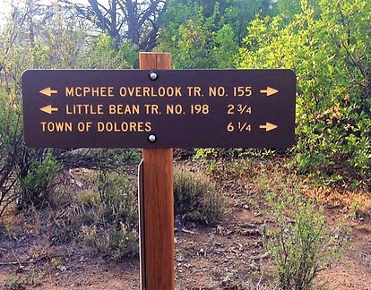

This trail is open to all non-motorized, so you'll see horseback riders, bikers, plenty of pets, and sometimes no one at all. This is a seasonal trail, closing from December 1st thru April 15th to protect the winter range of many animals.
McPhee Overlook Trail has been incorporated into the Escalante Days Mountain Bike race that happens on the 2nd Saturday of August every year.
From the Town of Dolores, Turn onto B street near the Fire Station, then turn left onto Central Avenue and take the dirt road until it terminates at the Dolores Cemetery and the beginning of the Dolores River Trail. You'll see the trail marker signs.
Dolores - ormiston trail point loop
Gravel map - 68.15 miles

